|
Mt. Washington and Monroe Sept. 2 & 3, 2004 (Warning, this trip report is longer than the usual ones. This was a GOOD trip, and if you choose to read about it, I hope you feel almost like you went with us. But if not, there's a link to the photo gallery at the bottom of this page.) The weather report was for a couple of great days, and there were openings at Lakes of the Clouds hut, so we snagged two spots. Using the hut would allow us to leave sleeping bags and tent at home, plus supply an evening meal and breakfast, which would lighten the pack considerably. Our plan was to go up the Ammonoosuc Ravine Trail to the hut, drop some gear, and continue up to Monroe. Then stay at the hut and summit Washington the next day. The morning of the hike we parked at the Cog Railway Base
Station,
paying $5.00 for the privilege to leave the car there over night. I’d
heard the Ammonoosuc can be very difficult, with uncertain footing. That sure didn’t match the trail I hiked. I
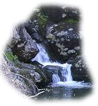
liked it. First you come to Gem Pool. Really pretty. Then, the guide book
says it’s a rough, very steep, ascent above the Pool, and We followed the head waters of the Ammonoosuc River, with great views along the way. The brook drops 600 feet at a 45% angle and it’s pretty impressive. Further up, the trail crossed the brook on ledges. We had to stop for picture taking many times. Soon left the trees behind and walked through short scrub. Before long that gave way to open ledges and we followed cairns marking the trail. We could see the hut perched way up on top of the ridge. More climbing and we were there. Checked in, picked our bunks and made our beds, in order to lay ‘claim’ to our choices. The bunks are 3 high. I took a bottom, and Joe took a middle one. Our bunk room had 15 bunks, so we knew we’d have plenty of company that night. The hut holds 90 hikers, and was either full, or near to it.
Climbing Monroe was easy til we got to one spot not mentioned in the guide book. A bit of rock climbing. I looked at it, and could see a cairn way up high, and decided I hadn’t come that far to turn back, so I found footing and finger holds and climbed up. Wasn’t that hard, but would have been easier if we had left the backpacks at the hut. No matter, we were soon at Monroe summit. The weather man sure was right! This was a beautiful day, with bright blue sky and gentle breeze. One of those perfect hiking days, and we were lucky enough to be on top of the 4th highest of the 4K list. Sometimes things go right. There were a few people on the summit. One took our picture for us. We wandered around the exposed rocks, taking in the views. The southern Presidentials were all lined up in a row. We’d done all the southern Presies except for Monroe, so now they were completed. It felt good to have another group of mountains done, but in a way I was sorry to see the end of them. I’ve enjoyed the southern Presies more than any other group. Mostly, these mountains have been kind to us. We got caught on Eisenhower in an ice storm one August, and had to turn back, but even with that, I can say all our hikes into these mountains have been fun. There’s a path that by-passes the Monroe summit and we looked down on
it from above. Golden Looked north, and there was Washington, huge, even from our present elevation. Hardly a cloud to be seen, and deep blue sky surrounded the summit. Beautiful. Eventually it was time to head back to the hut. Supper would be served promptly at 6:00 and we wanted time to stash our gear and get squared away. I had a little trepidation about the near vertical spot of rock climbing. It wasn’t terribly long, but you sure would break a few things if you fell. Turned out to be easier than climbing up. The trail back to the hut was fun because the whole way you’re facing views to Washington, with it’s western slopes, and the ridge north to Jefferson. The landscape is incredibly beautiful. At the hut we stowed gear, and went back outside to wait for dinner. Other hikers lounged on the rocks and benches near the hut. People had spread sweaty shirts in the sun to dry. Hikers were wearing every imaginable kind of clothing, from wool shirt and Smoky Bear type hat, to men in black tights beneath shorts and a beanie on their head. In the valleys style rules, but in the mountains practicality rules. We relaxed and watched and listened to the other hikers. Two older people, a man and a woman, strangers I think, were telling tales of their past climbs in the area, and of tragic deaths in the Presidentials. A reminder that while we were enjoying comfort and incredible weather, the conditions can change rapidly. |
|
|
Site and contents copyright © 2002-07 Eaton's Studio |
|
|
|
 "may prove quite
arduous to many hikers". I guess I was asleep while I cruised up that, as
I never saw anything that fit that description. A couple places I sat down
to clamber over a rough spot. There were some ledges where you had to stop
and look for hand holds, but it was much milder than Tripyramid.
"may prove quite
arduous to many hikers". I guess I was asleep while I cruised up that, as
I never saw anything that fit that description. A couple places I sat down
to clamber over a rough spot. There were some ledges where you had to stop
and look for hand holds, but it was much milder than Tripyramid. 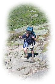 Left the hut and headed for Mt. Monroe, the 4th highest of
the mountains on our list. The trail was well groomed, with stones on
either side of the tread way. That’s to encourage people to walk on the
trail and not trample the rare alpine plants. Walk on durable surfaces
they say, meaning on rocks, and not on plants.
Left the hut and headed for Mt. Monroe, the 4th highest of
the mountains on our list. The trail was well groomed, with stones on
either side of the tread way. That’s to encourage people to walk on the
trail and not trample the rare alpine plants. Walk on durable surfaces
they say, meaning on rocks, and not on plants. 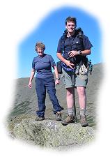 alpine grass waved in the breeze, and hikers were
little dots moving along the trail. As we looked south over the tops of
the other Presidentials we could see the trail for a long distance, very
clearly defined.
alpine grass waved in the breeze, and hikers were
little dots moving along the trail. As we looked south over the tops of
the other Presidentials we could see the trail for a long distance, very
clearly defined.