Well, everyone who hikes around these mountains knows about Garfield Ridge and all it’s PUD’s (pointless ups and downs). About this time I was beginning to think she was perhaps a bit negative, and so maybe Falling Waters wouldn’t be as bad as she indicated.
One of our roommates was the current ecology expert at the hut, there to educate people about the rare plants living in the tundra region of the upper ridges. He came into the bunk room while we were packing. As I slipped my feet into my still soggy boots, I asked him what he thought of going down Falling Waters. He said he’d done that many times, but it had some very slippery places, and crossed the top of a waterfall on wet ledges. He always fell two or three times going down.
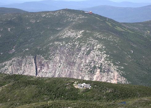
The hut croo had announced the weather report from the summit of Washington. It was experiencing 60 mile an hour wind gusts. We headed for Lafayette summit, hoping the wind was not strong there. As we climbed, incredible views opened up. We could see the trail, Eagle Lake, and the hut, perched high on Agony Ridge. Right behind it the land drops off sharply into Franconia Notch and Rt. 93. Just on the other side of the Notch the impressive Cannon Cliffs rise high into the air, topped with the green slopes of Cannon Mountain Ski Area.
At the summit we noticed none of the other hikers were hanging around long, and knew we shouldn’t either. We did our ritual summit handshake, and took a few pictures. The weather looked okay, the wind wasn’t strong, and although we knew things could change rapidly, we decided to cross the ridge.
After a couple of stops along the way to Mt. Lincoln, I began to realize a few things that didn’t make me happy. My soggy boots were taking a toll on my feet. A knee problem was flaring up and I had to be careful with each step. My eye had compressed the distance from Lafayette to Lincoln. It was really much further than it had seemed. The sky to the west was not looking as pleasant as it had in the early morning, and I suspected I heard distant thunder.
After passing through scrub in a 4,900' col we climbed to a nameless hump that topped out at 5,020'. I wasn’t altogether pleased to see that if I slipped while crawling up there I was in for a fall down the side of the mountain. I looked for handholds, and up I went, somewhat surprised I made it. Joe followed with less difficulty, as he has a longer reach. Down the other side of this and we were back down into a 4,900' saddle. Then the final climb to Lincoln.
I’d planned to eat lunch on the summit of Lincoln, but a look at the skies changed my mind. A storm was coming in, and we still had to descend Lincoln and cross the Knife Edge to Little Haystack before we could drop below treeline. After the experiences of the day before, I knew I didn’t want to be up here when weather hit. I told Joe we couldn’t take the time to stop and eat, and he said he knew. I worry at the drop of a hat, but Joe doesn’t give up his food easily. If he wanted to move on without eating, it meant he, also, was concerned. We still had plenty of trail snacks, so we nibbled on them as we hiked.
The path down from Lincoln to Little Haystack crosses beautiful terrain. It certainly is a knife edge, in some places. The slopes to either side were often mossy, and we began to see the occasional flower. This was the nicest part of the trail we walked that day. The footing was good enough so we could look around rather than concentrate on where we placed our feet.
At the summit of Little Haystack, I again considered stopping for lunch, but now there was no doubt I could hear thunder. We headed west on Falling Waters, losing elevation quickly. Once below treeline we stopped to eat. Two days of hiking with no lunch had taken it’s toll. We were exhausted. Joe got out cheese, crackers, cookies, and Gatorade. We had a stick of pepperoni, but it seemed like too much work to eat it.
|
|
|
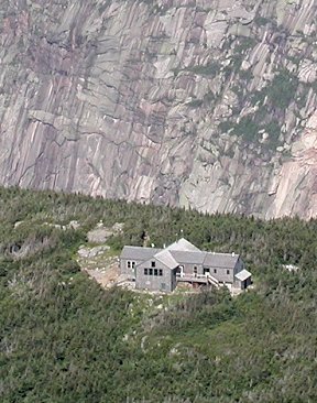
| Close up view of Greenleaf Hut, with Cannon Cliffs in background. |
 |
| Behind the hut the land drops steeply into Franconia Notch. on the other side of the notch can be seen Cannon Mt. Ski Area. |
 |
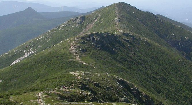
| Trail between Lafayette and Lincoln. Hiker can just be seen as a tiny dot on the trail, in the foreground. Pointed mountain to left is Flume. |
 |
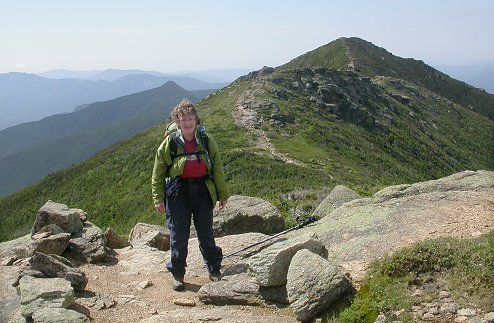
| Mabel on Franconia Ridge. Mt. Lincoln in background. |
 |
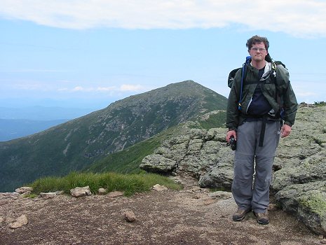
| Joe on the summit of Mt. Lincoln. Lafayette in the background. |
 |